We love to visit Mammoth Lakes in the summer. This sleepy little ski town high in the Sierra Nevada mountains, is one of the best kept secrets in California. Although I love Europe, it's just a wee-bit too crowded, not to mention way too hot in July and August. In Mammoth, however, summer temps rarely peek above 80 degrees. Nighttime temps are downright balmy. Once the snowboarders and skiers leave come late May, the mountain bikers, anglers, and of course, hikers take over the hamlet. The vibe in town and on the mountain becomes laid back, mellow, halcyon. If you're looking for some peace, quiet, and some spectacular views, then Mammoth is for you.
That's where we come in. We head to Mammoth every summer for some serious High-Sierra trekking. Mammoth and its surrounding area is home to literally hundreds of hiking trails short and long, easy and strenuous. And nearly all are punctuated with either a pristine lake or clear-running stream, perfect for casting your fishing pole or just soaking your toes.
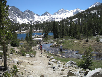
One of our favorite day hikes is a trail known as Little Lakes Valley. It's located at the end of Rock Creek Road, a few miles south of Tom's Place (about a 20-minute drive south of Mammoth Lakes). Since the trailhead, Mosquito Flats, stands at an astounding 10,300 feet, much of the journey is relatively flat making it perfect for leisurely adventurers with kids. But the surrounding scenery is anything but flat! Like the name implies, the trail meanders through a deep bowl surrounded by towering snow-capped peeks and past a series of lakes and streams, one more beautiful than the next.
Above is Marsh Lake, our first stop. To reach this rocky lookout about a mile or so from the trailhead, take a side trail to the left at the beginning of the lake, and then scramble up slick rock for this breathtaking view.
A clear-water stream runs parallel to the trail and leads to Heart Lake. Look for the small waterfall in the southern corner of the lake.
The trail then climbs above Box Lake, a great fishing hole. If you're careful, you can scramble down the rocky cliff and head to the shore.
Next, you'll rise a bit in elevation as you approach Long Lake, a perfect spot for a picnic along its grassy shore.
The trail then winds along a rocky Morgan Creek before the final ascent to Mt. Morgan (13,748 feet), off in the distance.
At more than 11,000 feet, the landscape at Morgan Pass looks almost lunar-like. Upper Morgan Lake is off in the distance and just a short hike ahead. It's a good spot to rest and ultimately turn around and head back.
If you do decide to hike all the way to Morgan Pass, count on a full day. Bring plenty of water as there is none available on the trail.
Happy Trails.


